Email: hello@saveohioparks.org

Nominations

Egypt Valley Wildlife Area 

Nomination #26-DNR-0009

This application is to frack 5 parcels totaling 863.205 acres of Egypt Valley Wildlife Area in Belmont County from unspecified well pads more than 1000 feet away.
Learn More
Egypt Valley Wildlife Area 

Nomination #26-DNR-0008

This application is to frack 3 parcels totaling 777.712 acres of Egypt Valley Wildlife Area in Belmont County from unspecified well pads more than 1000 feet away.
Learn More
Egypt Valley Wildlife Area 

Nomination #26-DNR-0007

This application is to frack 7 parcels totaling 1285.913 acres of Egypt Valley Wildlife Area in Belmont County from unspecified well pads more than 1000 feet away.
Learn More
Egypt Valley Wildlife Area 

Nomination #26-DNR-0006

This application is to frack 21 parcels totaling 5439.743 acres of Egypt Valley Wildlife Area in Belmont and Guernsey counties from unspecified well pads more than 1000 feet away.
Learn More
 

Nomination #26-DNR-0005

This application is to frack 7 parcels totaling 746.85 acres of Egypt Valley Wildlife Area in Belmont County from well pads more than 1000 feet away.
Learn More
 

Nomination #26-DNR-0004

This application is to frack 5 parcels totaling 849.881 acres of Egypt Valley Wildlife Area in Belmont County from well pads more than 1000 feet away.
Learn More
Salt Fork State Park 

Nomination #26-DNR-0003

This application is to frack 7 parcels totaling 513.11 acres of Salt Fork State Park in Guernsey County from well pads over 1000 feet away.
Learn More
 

Nomination #26-DNR-0002

This application is to frack 8 parcels totaling 2792.67745 acres of Egypt Valley Wildlife Area in Belmont County from well pads over 1000 feet away.
Learn More
 

Nomination #26-DNR-0001

This application is to frack 14 parcel totaling 3846.934 acres of Egypt Valley Wildlife Area in Belmont County from well pads more than 1000 feet away.
Learn More
Map for nomination 26-DOT-0004 

Nomination #26-DOT-0004

This application is to frack 1 parcel containing .998 acres in Stark County along SR 30 from a well pad 1.3 miles away.
Learn More
Map of 2026 third nomination for DOT land for fracking 

Nomination #26-DOT-0003

This application is to frack 1 parcel containing 14.743 acres in Guernsey County along Interstate 70 from a well pad 1.3 miles away.
Learn More
 

Nomination #26-DOT-0002

This application is to frack 1 parcel containing .279 acres in Guernsey County along SR 513 from a well pad more than 1000 feet away.
Learn More
 

Nomination #26-DOT-0001

This application is to frack 2 parcels containing 18.71 acres in Guernsey County along SR 513 from a well pad 1615 feet away.
Learn More
Former coal mine site in Jockey Hollow Wildlife Area before (inset) and after reclamation efforts, by Keith E. Gilland and Brian C. McCarthy, Restoration Ecology, November 2013. 

Nomination #25-DNR-0002

This application is to frack 21 parcels totaling 1460.559 acres of Jockey Hollow Wildlife Area in Harrison County from unspecified well pads.
Learn More
 

Nomination #25-DNR-0001

This application is to frack 1 parcel totaling 366.495 acres of Egypt Valley Wildlife Area in Belmont County from a well pad 2.83 miles away.
Learn More
 

Nomination #25-DRC-0001

This application is to frack 1 parcel totaling 6.881 acres under Noble Correctional Institution from a well pad 2.53 miles away.
Learn More
 

Nomination #25-DOT-0012

This application is to frack 1 parcel containing .823 acres in Guernsey County along SR 513 from a well pad 3,993.13 ft away.
Learn More
 

Nomination #25-DOT-0011

This application is to frack 1 parcel containing 22.426 acres in Belmont County along SR 7 from a well pad 2.44 miles away.
Learn More
 

Nomination #25-DOT-0010

This application is to frack 22 parcels containing 18.393 acres in Belmont County along SR 7 from a well pad 1.7 miles away.
Learn More
 

Nomination #25-DOT-0009

This application is to frack 3 parcels containing 6.875 acres in Tuscarawas County along SR 800 from a well pad 1.52 miles away.
Learn More
 

Nomination #25-DOT-0008

This application is to frack 1 parcel containing 0.129 acres in Guernsey County along SR 265 from a well pad 2.05 miles away.
Learn More
 

Nomination #25-DOT-0007

This application is to frack 1 parcel containing 11.852 acres in Monroe County at the Woodsfield Outpost along SR 26 from a well pad 3.05 miles away.
Learn More
 

Nomination #25-DOT-0006

This application is to frack 5 parcels containing 1.163 acres in Columbiana County along SR 558 from a well pad 2.18 miles away.
Learn More
 

Nomination #25-DOT-0005

This application is to frack 1 parcel containing 14.743 acres in Noble County along SR 78 from a well pad 2.53 miles away.
Learn More
 

Nomination #25-DOT-0004

This application is to frack 1 parcel containing 0.91 acres in Noble County along SR 78 from a well pad 2.52 miles away.
Learn More
 

Nomination #25-DOT-0003

This application is to frack 1 parcel containing 2.615 acres in Tuscarawas County along SR 800 from a well pad 0.44 miles away.
Learn More
 

Nomination #25-DOT-0002

This application is to frack 1 parcel containing .996 acres in Tuscarawas County along SR 800 from a well pad 0.44 miles away.
Learn More
 

Nomination #25-DOT-0001

This application is to frack 1 parcel containing 3.245 acres in Tuscarawas County along SR 800 from a well pad 0.42 miles away.
Learn More
24-DNR-0012 

Nomination #24-DNR-0012

This application is to frack 8 parcels totaling 382.810 acres of Jockey Hollow Wildlife Area in Belmont and Harrison Counties from a well pad 1,000+ feet away.
Learn More
 

Nomination #24-DNR-0011

This application is to frack 20 parcels totaling 4,360 acres of Egypt Valley Wildlife Area in Belmont County from a well pad 1,000+ feet away.
Learn More
 

Nomination #24-DNR-0010

This application is to frack five parcels totaling 3.64 acres of Valley Run Wildlife Area in Carroll County from a well pad 1.69 miles away.
Learn More
 

Nomination #24-DNR-0009

This application is to frack 171.64 acres of Leesville Wildlife Area in Carroll County from a well pad 2.07 miles away.
Learn More
 

Nomination #24-DNR-0008

The application is to frack 513.11 acres of Salt Fork State Park in Guernsey County from well pads 9,000 feet away.
Learn More
 

Nomination #24-DNR-0007

The application is to frack 371.42 acres of Salt Fork State Park in Guernsey County from well pads 16,415 feet away.
Learn More
 

Nomination #24-DNR-0006

This application is to frack 65 acres of Leesville Wildlife Area in Carroll County from a well pad 2.32 miles away.
Learn More
 

Nomination #24-DNR-0005

This application is to frack 62.49 acres of Leesville Wildlife Area in Carroll County from a well pad 2.76 miles away.
Learn More
 

Nomination #24-DNR-0004

The application is to frack 257 parcels of Salt Fork State Park and Salt Fork Wildlife Area with four well pads 1443 to 3893 feet away.
Learn More
 

Nomination #24-DNR-0003

The application is to frack 30 acres in Flushing Township, Belmont County, comprising part of Egypt Valley Wildlife Area with one well pad 2 miles away.
Learn More
 

Nomination #24-DNR-0002

The application is to frack 85 acres in Washington Township, Harrison County, comprising all of Keen Wildlife Area with one well pad less than a mile away.
Learn More
 

Nomination #24-DNR-0001

The application is to frack 366.6 acres in Kirkwood Township, Belmont County, comprising part of Egypt Valley Wildlife Area with one well pad 2.83 miles away.
Learn More
24-DOT-0015 

Nomination #24-DOT-0015

This application is to frack 7 parcels totaling 9.886 acres along SR 821 and Seneca Road in Valley Twp, Guernsey County, from a well pad 2.45 miles away.
Learn More
 

Nomination #24-DOT-0014

This application is to frack 32 parcels totaling 52.619 acres along SR 7 in Mead Twp, Belmont County, from a well pad 1.7 miles away.
Learn More
 

Nomination #24-DOT-0013

This application is to frack three parcels totaling .669 acres along SR 151 in Monroe Twp, Harrison County, from a well pad 2.5 miles away.
Learn More
 

Nomination #24-DOT-0012

This application is to frack one parcel totaling .179 acres along SR 149 in Smith Twp, Belmont County, from a well pad .93 miles away.
Learn More
 

Nomination #24-DOT-0011

This application is to frack one parcel totaling 4.7 acres along SR 800 in Center Twp, Monroe County, from a well pad over 2.3 miles away.
Learn More
 

Nomination #24-DOT-0010

This application is to frack one parcel totaling .823 acres along SR 513 in LondonderryTwp, Guernsey County, from a well pad over 1000 feet away.
Learn More
 

Nomination #24-DOT-0009

This application is to frack four parcels totaling 26 acres along Interstate 77 in Valley Twp, Guernsey County, from a well pad 2.68 miles away in Noble County.
Learn More
 

Nomination #24-DOT-0008

This application is to frack one parcel totaling 179 acres along Interstate 77 in Buffalo Twp, Noble County, from a well pad 1.71 miles away.
Learn More
 

Nomination #24-DOT-0007

This application is to frack five parcels totaling 70 acres along Interstate 77 in Jackson Twp, Guernsey County, from a well pad 2.36 miles away.
Learn More
 

Nomination #24-DOT-0006

This application is to frack three parcels totaling 28 acres along Interstate 70 in Wills Twp, Guernsey County, from a well pad 1458 feet away.
Learn More
 

Nomination #24-DOT-0005

This application is to frack three parcels totaling 1.2 acres near State Route 265 in Belmont County, from a well pad .29 miles away.
Learn More
 

Nomination #24-DOT-0004

This application is to frack one parcel of 2.8 acres near State Route 26 in Belmont County, from a well pad .87 miles away.
Learn More
 

Nomination #24-DOT-0003

This application is to frack one parcel near State Route 78 in Monroe County, from a well pad 2.9 miles away.
Learn More
 

Nomination #24-DOT-0002

This application is to frack five parcels near State Route 331 in Belmont County, from a well pad .75 to 2.2 miles away.
Learn More
 

Nomination #24-DOT-0001

This application is to frack eight parcels near State Route 7 in Monroe County, from a well pad 3.65 miles away.
Learn More
 

Nomination #23-DNR-0010

The application is to frack 148 parcels in three townships of Guernsey County comprising part of Salt Fork State Park with nine well pads as close as 395 feet from the park border.
Learn More
Salt Fork Nomination 2 fracking lateral map 

Nomination #23-DNR-0009

The application is to frack 446 parcels in six townships of Guernsey County comprising all 20,000 acres of Salt Fork State Park with an unspecified number of frack pads in unknown locations.
Learn More
Wolf Run nomination frack laterals 

Nomination #23-DNR-0008

This application is to frack all 1000 acres of Wolf Run State Park and 1000 acres of the surrounding area in Noble County. The nomination does not indicate how many frack pads or where they would go.
Learn More
Salt Fork State Park 

Nomination #23-DNR-0007

This application is to frack a total of 22 parcels in Salt Fork State Park with three well pads surrounding the park in three townships of Guernsey County. The well pads would be 1,547 to 2,245 feet from the park boundary.
Learn More
Salt Fork State Park 

Nomination #23-DNR-0006

This application is to frack a total of 83 parcels in Salt Fork State Park with five well pads surrounding the park in three townships of Guernsey County. The well pads would be 400 to 7,600 feet from the park boundary.
Learn More
Salt Fork State Park 

Nomination #23-DNR-0005

This application is to frack a total of 176 parcels in Salt Fork State Park with eight well pads surrounding the park in three townships of Guernsey County. The well pads would be 406 to 6,132 feet from the park boundary.
Learn More
Zepernick Wildlife Area 

Nomination #23-DNR-0004

This application is to frack one parcel in Zepernick Wildlife Area in Columbiana County. The parcel is 66 acres to be fracked from a well pad 3.67 miles away.
Learn More
Valley Run Wildlife Area 

Nomination #23-DNR-0003

This application is to frack almost the entirety of Valley Run Wildlife Area in Carroll County. The parcel is 302 acres, to be fracked from a well pad 1.89 miles away and a second well pad 692 feet away.
Learn More
Valley Run Wildlife Area 

Nomination #23-DNR-0002

This application is to frack a single parcel in Valley Run Wildlife Area in Carroll County. The parcel is .07 acres on a residential street, to be fracked from a well pad 2.26 miles away.
Learn More
Valley Run Wildlife Area 

Nomination #23-DNR-0001

This application is to frack a single parcel in Valley Run Wildlife Area in Carroll County. The parcel is .05 acres on a residential street, to be fracked from a well pad 2.55 miles away.
Learn More
 

Nomination #23-DOT-0008

This application is to frack 8 parcels along SR 761 from an unspecified number and location of well pads in Noble County.
Learn More
 

Nomination #23-DOT-0007

This application is to frack 4 parcels along Industrial Park Road and Cadiz-New Athens Road from an unspecified number and location of well pads in Harrison County.
Learn More
 

Nomination #23-DOT-0006

This application is to frack 17 parcels along the Interstate 470 Corridor from an unspecified number and location of well pads in Belmont County.
Learn More
 

Nomination #23-DOT-0005

This application is to frack 66 parcels along SR 7 from an unspecified number and location of well pads in Belmont County.
Learn More
 

Nomination #23-DOT-0004

This application is to frack 5 parcels along SR 800 from a proposed well pad 1200 to 1600 feet away and 1 parcel along SR 148 from a proposed well pad 10,000 feet away, all in Belmont County.
Learn More
DOT Malvern Outpost map 

Nomination #23-DOT-0003

This application is to frack one parcel of 2.62 acres at the Department of Transportation Malvern Outpost from a proposed well pad 1.7 miles away.
Learn More
OH_154_map by Mr. Matté 

Nomination #23-DOT-0002

This application is to frack 31 parcels near State Route 154 in Columbiana County County. The parcels total 42.9 acres to be fracked from a well pad 4,673 feet away.
Learn More
Ohio State Route 151 map 

Nomination #23-DOT-0001

This application is to frack a single parcel near State Route 151 in Harrison County. The parcel is 9 acres to be fracked from a well pad 2.49 miles away.
Learn More

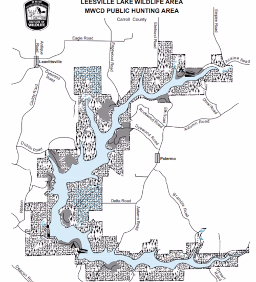
This page contains a list of Ohio public lands that the oil and gas industry has nominated for extraction — meaning they have applied to the Oil and Gas Land Management Commission to frack on these lands.

Each nomination contains a location of the parcel or parcels; which state agency manages that location; whether it is in a state park, forest, or wildlife area; and the deadline for submitting public comments.

You can submit comments on open nominations at the Nomination Comment Portal. Be sure to select the correct nomination number at the top and submit your comment by the deadline.

You are donating to : Save Ohio Parks

How much would you like to donate?
$25 $50 $100
Would you like to make regular donations? I would like to make donation(s)
How many times would you like this to recur? (including this payment) *
Name *
Last Name *
Email *
Phone
Address
Additional Note
paypalstripe
Loading...